About GeOrg
GeOrg is an application for paperless geocaching. In short you can
- load GPX-Files from Groundspeak or GSAK,
- list, view and sort caches,
- view caches on a map,
- and go on the treasure-hunt with the built-in compass or the map.
|

|
GeOrg is currently only available on the Android Market at a price of €4.99. If you decide to buy it, you are entitled to install all future updates of the software on your device.
Screenshots
Some pictures to say more than words …
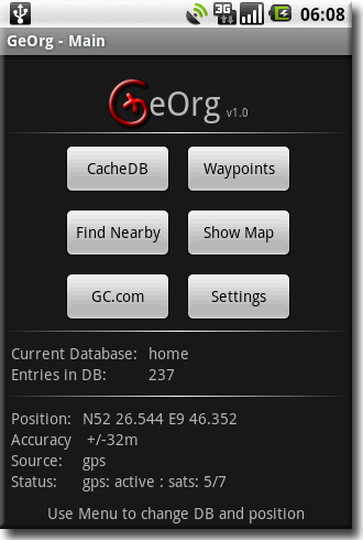
The entry-point of GeOrg – the Main-Page allows you to change your location provider and manage Cache-Databases.
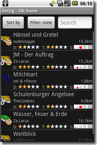
A Cache-Database – manage your caches.
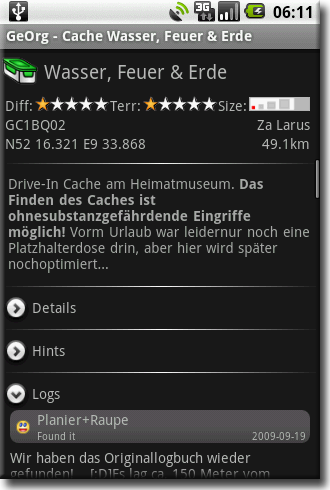
A Cache-Listing
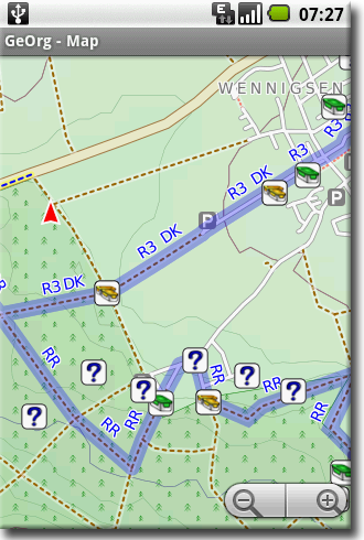
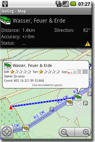
The Map – check your position and discover nearby caches. This picture showcases the OpenStreetMap-CycleMap-Layer. Of course, GoogleMaps are also available.
The Map – let GeOrg guide you to your favorite tupperware-box.
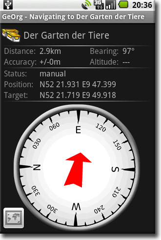
The Compass – if you prefer, a compass is also available.
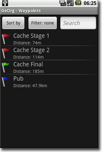
Waypoints – mark waypoints during the hunt or remember that cozy inn along the way.
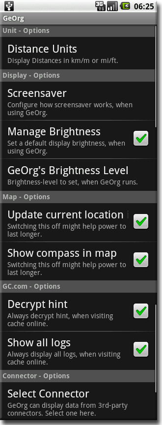
Settings – configure GeOrg.
Detailed Featurelist
| Import Interface |
| Import Geocaches from |
- GPX-Files
- Multiple GPX-Files in one directory
- Zipped GPX-Files
- Mail-Attachment (GPX-Files, Zip-Files)
|
| Import Waypoints from |
GPX-Files
|
| Import Routes from |
GPX-Files
|
| Import Tracks from |
Not yet available
|
| Tested GPX-Formats |
- geocaching.com
- GSAK
- opencaching.de
- GeoToad
- CacheWolf production- and nightly build
- GC-Tour
|
| Main-Menu |
| Features |
- Create/Delete/Switch between CacheDBs
- Switching Location Provider
- Select internal or external (SD-Card) storage for CacheDBs
- Move all data between internal and external storage
- CacheDB-Health-Check
|
| CacheDB |
| Features |
- List geocaches with attributes: Name, type, diff, terr, size, owner, distance and direction, tb- and found-state
- Waypoint projection
- Incremental search by name and gc-code
- Filter geocaches by found / dnf / not yet found
- Sort geocaches by name, distance, type, difficulty, terrain, size
- Delete single/all geocaches
|
| CacheListing |
| Features |
- Data for single geocache displayed on single page with expandable subsections
- Long- and short-description as html, copy and paste enabled, optionally show html-source for long-description
- Optionally display GCVote-status of cache
- Show/Add/Edit/Delete Additional Waypoints
- Show TBs with link to geocaching.com-page
- Show spoilers if made available on sd-card (spoiler-pictures are not included in GPX-files)
- Show Logs
- Show Hints
- Ability to store and edit a comment for each geocache
|
| Compass |
| Features |
- Show distance, altitude, bearing/heading, accuracy, position, target-position
- Add new waypoint directly from Compass-Page
|
| Map |
| Features |
- Show Caches, additional waypoints and global waypoints
- Source of data: Current CacheDB or live-data from connector (if available)
- Google Maps, Satellite Map, Mapnik, Osmarender, Terrain, Cyclemap
- Ability to use one map obtained by “trekbuddy” in andnav2-format offline from sdcard
- Navigation to geocaches/waypoints offroad or on road (needs internet connection)
- Save current on road navigation as offline-route
- Lock map-center to current position
- Create waypoints by tapping the map
- Target-Display visible when target is defined information about distance, bearing, altitude, satellite-state etc.
|
| Field Notes |
| Features |
- Write Field Notes in CacheDBs, Cachelistings and on the map.
- Export Field Notes to sd-card or mail (Android 2.0+ only)
|
| Waypoints |
| Features |
- Global waypoints are kept in separate storage
- Additional waypoints are assigned to one cache in the CacheDB
- Create/Delete/Edit Waypoints with comments
- Import/export common waypoints from/to GPX
- Switch single waypoints from global waypoints to additional waypoints and back
|
| Routing |
| Features |
- Offroad (map / compass)
- Onroad (in-application solution displays route and geocaches in one map, needs internet connection)
|
| Access external datasources |
Via external connector.
Connectors available: |
|
| Location |
| Features |
- GPS / Cell / Wifi / Manual
- Tracklog / Proximity alert: planned, not available at the moment
- Experimental waypoint-averaging available in Waypoint dialog
- Geocoding available in waypoint dialog (getting coordinates for location by name (e.g. “Wall Street, NY”))
|
| GUI |
| Features |
- Day / Night / Auto-Switch-Theme
|
| Solvers |
| Features |
- Caesar cypher
- Roman numbers
- Vanity numbers
- Morse code
- Sun & Moon related calculations
- more coming in the near future…
|
| Other information |
| |
- Geodetic datum: WGS84
- In development since March 2009
- Published on Sep. 27th 2009
- Download size: approximately 700KB
- Developed under 1.6
- Compatibility: Android 1.5 – 2.1
- Density: low – high
- Major releases about every 1-2 months
- Bugfix releases as soon as necessary/possible
- Current version: 1.1.7.3
- Availability: Currently only available on the Android Market
|
How GeOrg is developed
GeOrg came into existence shortly after we got our first android-device early 2009. Starting as an exercise in android-programming it quickly evolved into a full-blown application.
GeOrg started as a replacement for the multitude of print-outs that we used to carry on our geocaching-hikes. As such, it was meant to complement a traditional GPSr. At some point though, we decided that we also needed a stand-alone solution for spontanous geocaching without a dedicated GPSr, so we put some compass-functionality into GeOrg.
We even implemented in-application queries for geocaches from Groundspeak’s website to display them in lists and maps. Unfortunately the emails we sent to Groundspeak in order to get a statement from them about how they judge this functionality considering their sites Terms of Use were never answered.
So we decided it was safer to remove all Groundspeak related code from GeOrg and instead support a plugin-interface for external datasources. If you are a developer, you might be interested in the sourcecode of our example-project that is available here.
About ranitos
We are a couple from Hannover, Germany who develop for android in our spare time. We are also avid geocachers since 2007 and of course we use GeOrg for caching next to our 60Csx. As you can imagine, we ourselves are our most diligent beta-testers, since every bug in GeOrg hampers our own geocaching-experience. Also our wishlist for future release of GeOrg is still quite long, so stay tuned for more features to come.