Obtaining a GPX-File
GPX-Files are the basis of all cache-data in GeOrg. The GPX-Format is the de-facto XML standard for sharing GPS-data (waypoints, routes, tracks) between “geo-aware” applications. Groundspeak has extended the standard to accomodate for cache-relevant data like terrain, cache-descriptions or travelbugs.
GeOrg is tested to import GPX-Files from Groundspeak and GSAK, a versatile cache-management software for Windows. Furthermore, GPX-imports work for data from GCTour, geotoad and Cachewolf.
Getting a GPX-file from Groundspeak
Groundspeak offers the ability to export GPX-data directly from their database via “Pocket Queries” to paying premium members. A Pocket Query is like an agent running on Groundspeaks database and exporting data on your behalf. To get it running, you have to give it an assignment containing the data you want returned. This assignment contains information like …
- the location you want to get cache-data from,
- the radius around your location you want included in your search,
- the type of caches you want returned,
- the difficulty- and terrain-maximum or -minimum values for returned caches or
- whether you want to run it once or on a regular basis
After you submit the Pocket Query to Groundspeak it will run as soon as Groundspeak has resources to run it and return your GPX-file via email. Also, you can download the GPX-file directly from the site. You can not always rely on timely execution though, so don’t rely on last minute Pocket Queries.
There are some restrictions on Pocket Queries, that you should be aware of, the most noticable being:
- Pocket Queries are only available to Groundspeak Premium Members, meaning you have to pay a small fee to Groundspeak every month.
- You can get a maximum of 500 caches returned (or a maximum of 1000, but these won’t get sent via email)
- A maximum of 5 queries can be run on a single day.
If you want to try out Pocket Queries right now, you can get started (premium membership provided) here. There’s also a small walkthrough provided by Groundspeak.
Exporting GPX-data from GSAK
Another way to obtain GPX-files is to export them from some sort of GPX-exporting software. GeOrg has been tested with GSAK and other tools to do that job. How you get your cache-data into these applications in the first place is up to you, though 🙂
The export function in GSAK is located in the File-Menu under “Export” – “GPX/LOC File”. You can easily export a GPX-file from GSAK, that GeOrg will not understand, so here are two screenshots detailling the relevant export-options:
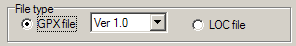
Ok, it should be clear by now, that you need a GPX-File. The version doesn’t really matter, GeOrg copes with both.
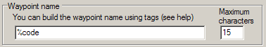
This is really important. The code (meaning something like GC12345) is very relevant to GeOrg. Allthough within the application caches are rather shown by their name, GeOrg internally relies on the uniqueness of this code, so you better keep it as the waypoint name.
Futher …
Ok, now you have your GPX-file – how do you import it? Read further …