Street-Navigation with Georg
If the geocache you’d like to do is a greater distance away you can use GeOrg’s street-navigation (since version 1.1.0). This is a simple internal navigation mechanism. It depends on an online-connection to request routing-information, so it doesn’t work if there’s no network available.
Also, features you are used to from a dedicated street-navigation-device or -software are missing in GeOrg: It won’t tell you streetnames or distances like a normal turn-by-turn-solution does and it doesn’t give audio-clues (yet) when you have to make a turn. It simply displays the route in the map.
Therefore we don’t recommend using it during the ride if you are driving alone. We recommend having a second person next to the driver checking the route (and caches nearby) while the driver can concentrate on the road.
Finally, routing and mapping isn’t failsafe. Errors may occur, maps may be outdated or incomplete, roads may be blocked, the routing service may not know about local traffic rules or … you get the notion. Please, do yourself and us a favor and always drive carefully, responsible and don’t rely on street-navigation to get everything done right.
That said …
How does Street Navigation work in GeOrg?
You can start a navigation from anywhere in the application:
- From a CacheDB: long-click on one of the items and select “Navigate to”
- From the WaypointPage: also, long-click on one of the items and select “Navigate to”
- From the MapPage: Click on one of the items on the map and click on the appearing bubble. Here select “Navigate to”.
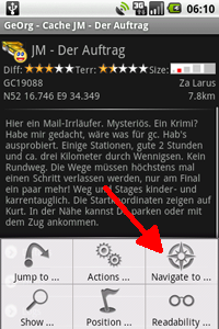
- From a CacheDetailsPage: select “Navigate to” from the Menu of the page
Here’s an example from the CacheDetailsPage:
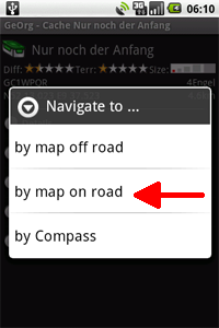
In all cases you will get a choice of navigation-options. These are:
- … by compass(not from the map): switches on offroad-navigation and brings you to the CompassPage
- … by map off road: also switches on offroad-navigation but brings you to the map
- … by map on road: this is what we want – it switches on street-navigation and also brings you to the map
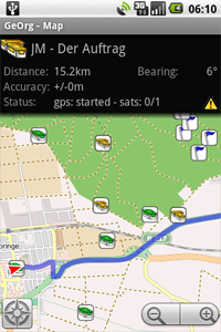
When entering the map with a street-navigation active and gps fixed you will notice a toast coming up telling you “Recalculating Route”. This is when GeOrg goes online to get the route-data from the internet. If it succeeds in doing so you will see the route as a blue ribbon on the map a few moments later. This is how it should look:
Please be aware that the route is calculated without respect to your currently displayed map. That means if your map is outdated or not complete (may occur with OpenStreetMap in some areas) the routing service might know roads that your map doesn’t show yet. Or vice versa 🙂
Also, whenever you enter the MapPage while doing a street-navigation, the default for map display is “Lock to current position”. That means GeOrg will automatically scroll the map, so that your current position is always in the center of it.
If you pan the map manually, this lock is released. Clicking doesn’t break it, but moving your finger does and you are informed by a short message about this. If you want to reactivate the lock, either leave the MapPage and reenter it (e.g. by the compass-icon down left) or use the Menu-Key, choose “Position” and than “Lock to current position” or touch the small lock-icon in the upper left of the map
If you start routing from a position not accessible via road, GeOrg will draw an offroad route-segment to the beginning of the next street, to indicate where you should be heading to. If you choose to leave the route at any given point, GeOrg will notice that your distance to the route increases and after a short while begin to recalculate the route. You get a small notification message if this is the case.
The data-fields above the map tell you the routed (not off-road) distance to your final destination. The bearing however indicates the off-road direction to your target position. If you switch to the compass, you will get the off-road distance to your destination.
Next topic: Creating a Waypoint …