Advanced: Waypoint Projection
In some geocaches you are asked to go for a certain distance in a certain direction (often expressed in degrees (0° being North, 90° East, 180° South and 270° West). That’s easy to do, if you have to walk just a few meters in open terrain. But if you have to travel several hundreds of meters you’ll sure want a software to just calculate the coordinates of your final destination.
This process, calculating a new position from an old position with an offset in distance and direction is called waypoint projection. Since 1.1.0 GeOrg can do it, too 🙂
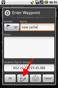
First you need a waypoint as a starting point. Create one or take an existing one from your WaypointPage. When you open that waypoint you’ll see the waypoint projection-button at the bottom:
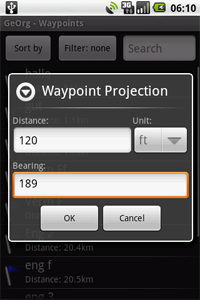
You’ll get a new dialog, where you are supposed to enter the offset data. Note that you can enter the distance in imperial or metric units.
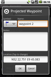
After clicking “OK”, you’ll get a new waypoint with the calculated position. Just give it a new name and you are done.