GeOrg version 1.1.2
This release fixes a lot of bugs that were sent to us in the last few days. Especially the map should now be much faster and more stable. A few little features also crept in ;-). See the changelog for details.
Like always: if you encounter any problems or crashes, please don’t hesitate to send them to us.
GeOrg – Droid compatibility
With the availability of the new Droid devices in the USA, we were made aware of an incompatibility between GeOrg and Android 2.0, which didn’t show up in our tests with the 2.0 emulator. Sadly the sourcecode of Android 2.0 still isn’t released, the Eclair-Branch is not yet visible.
We did however find the javadoc and – with the Eclair libs existing in the emulator in compiled form – were able to deduce a fix. This was our first experience with the Dedexer. It helped us a great deal!
If you’re having problems with GeOrg on a newly bought Droid device – just upgrade to version 1.1.1!
Got Bugs?
We have had a report about crashes sent to us via the “Sorry for crashing”-dialog
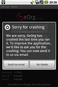
that never arrived at our bugreport-emailaccount. We haven’t figured out what happened, yet. But if you, too, sent us a bugreport and got no reply from us within 24 hours: please, contact us.
A walk in the woods – 60CSx vs GeOrg
On tuesday we finished work early for a short (4km/2.5mi) geocaching hike. The weather was fine, it was sunny and there’s a small woody mountain range called Deister (N52 15.400 E9 30.200) a few miles south from where we live with a massive amount of nice caches.
xel took our good old Garmin 60CSx, while I went with GeOrg on our G1. We did a multicache and 2 mysteries, of course we had solved those at home.
In preparation for our trip I downloaded the OpenStreetMap of the area the caches were in with TrekBuddy Atlas Creator. That area of the Deister has a lot of old quarries and you often lose network-connection. With the new offline maps I figured I’d be save in that respect.
I also did a small pocket query, just in case the multi would lead us to any traditionals along our way. Groundspeak was pretty quick this time and I imported the zipped GPX from the attachment directly on the G1.
The coordinates for the mysteries were quickly entered in the waypoint list and I was ready to go.
For our 60CSx I had to convert the pocket query to gdb-format which I always do with GSAK. Not as easy as importing a GPX-file with GeOrg, but at least it features a topographic map that doesn’t have to be prepared for each trip
Also I entered the mystery coordinates into MapSource rather than on the device, since that’s quite a hassle without a touchscreen.
While driving to the start-coordinate of the multi-cache I had GeOrg and the 60CSx both calculate and display the route. No surprises here, of course if I didn’t have connection to the routing service with my G1 the 60CSx (with CityNavigator) would have been superior here, but then again CityNavigator is quite expensive…
One thing the G1 is quite better at than the 60CSx is the time to first fix. We own a Peugeot 307 which has one of those GPS-hostile windshields. Both devices were placed at the windshield. The G1 had its fix a few seconds after we left the garage we parked at. The 60CSx struggled for nearly 10 minutes until it got the fix as we stood at a traffic light (standing still seems to help the 60CSx quite a lot under bad reception circumstances).
We safely arrived at Völksen, starting point of our hike. As we went into the woods, we compared our bearings and distances at nearly every waypoint. In sum we found 3 caches with a total amount of 6 waypoints, at 5 of them we compared our results:
- At one of the waypoints (open area, a lot of foliage though), the 60CSx and G1 agreed about the cache location.
- Once they were both off – that was in a deep and narrow quarry, lots of multipathing for sure.
- Three times, though, the 60CSx came out with better results than the G1, each time in open areas with huge trees and foliage above us. Usually xel would say something like “8m/26ft” while the G1 told me the cache was still 20-30m(65-100ft) away. 🙁
Often it seemed as if the G1 was in some kind of time-shift, always displaying the position we were at some moments ago. I’ll test this some more, especially as I’m already a little suspicous about the device doing some kind of filtering before handing out GPS-data to applications (see the new Waypoint averaging documentation)
Not to forget – we also had to do a waypoint projection at one of the mysteries. No problem with the new waypoint projection-option in GeOrg. Only problem was of course the sat-reception at that point. That time when I stood at the cache, the G1 still pointed 15m/50ft away. This in an area with dense foliage. We didn’t compare with the 60CSx at that point
As we went from waypoint to waypoint, xel had to enter all coordinates with the 60CSx’s “virtual keyboard” (if you don’t know it, think of entering your name into the highscore-list of some old video-game with a joystick), while I could enter the next target directly from the CompassPage (thanks to salmunya for that idea) with the touchscreen. Much easier and faster.
As always, when I’m geocaching I got my hands all dirty. The G1 was stowed away safely in a padded belt-bag, but as the hike went on, I became more and more reluctant to get it out and touch it. Something I just don’t care about when using the 60CSx. But that disadvantage was obvious to me before we even started 😉
Another disadvantage of the G1, its display when used in bright environments, was no big nuissance this time, since we were always moving beneath tree-foliage in the shadows. I could run the device at a very low brightness percentage. I’m sure, if we were geocaching in the sun, I’d have had much more problems with the G1, but the 60CSx screen is really hard to top.
During the 2 hours of our trip, GeOrg sucked up 25% of the battery. I constantly checked our position, but always made sure to shut down the display afterwards. Also I used the “Show compass on map”-setting which results in a lot more screen redraws than the non-directional icon you get without that setting. The 60CSx didn’t even lose one of it 20% bars during the whole trip.
To sum it all up
I’m a little bit disappointed with the G1’s GPS-performance in the field. And I’m quite curious about how tracklogs will differ as soon as I got them implemented in GeOrg :-).
The time to first fix on the other hand is perfect. Quick and reliable enough for starting traffic navigation. That’s a big plus for the G1, especially in our car 😉
Apart from that everything worked as expected. The G1 simply isn’t an outdoor device, but it’s still usable in those environments if you handle it with care, take some backup power-source with you or – and that’s what we are doing most of the time – use it only as a datasource and do the navigation with a dedicated GPSr.
But – if you’re more into traditionals, preferably only in short walking distance to your car, the G1 (with the right software ;)) may very well be the only device you’ll need.
GeOrg 1.1.0: Offline Maps
Now that GeOrg 1.1.0 is out, we are upgrading our documentation. We just finished the documentation for Offline Maps – a new feature that allows you to take your maps to places without network availability. Give it a try!
GeOrg 1.1.0 released!
We just released the latest version of GeOrg!
It’s now available via Android Market and contains a lot of features that people have asked for. The documentation will be upgraded within the next few days to highlight and explain some of the new features and there’s also a changelog-page coming up. Until then there’s a rough sketch of changes listed here. If you encounter any bugs, please feel free to contact us
Happy geocaching 🙂
GeOrg 1.1.0 is now beta
Just to keep you up-to-date: This evening we finished the last features for version 1.1.0. We’re now entering our internal beta test. Also, tomorrow we’re taking GeOrg out for some nightcache-fieldwork, our first geocaching-excursion since the 4th of october.
If all goes well and we don’t encounter any major bugs, the update will get published on the market within the next days. Stay tuned!
On our way to GeOrg v1.1.0
Today finally Donut arrived on our G1 and we just did some tests to check everything is allright. If you have any problems, as always: feel free to contact us.
One word of warning, though:
Donut resets all your CacheDBs, Waypoints and Settings. So if you are on the verge of a geocaching hike, you better have the GPXs prepared or postpone the update.
Other than that we are hard at work here at ranitos to bring you the new version of GeOrg. We’ve had a lot of feedback during the last days and we thank you all for your ideas, opinions and even a complete review, wow! 🙂
While we are crushing the last bugs, throwing in the last features and than move on to beta-test we’d like to share our current changelist for 1.1.0 for you to shorten the time 🙂
Features:
- Offline Maps (Tilepacks)
- Waypoint averaging (experimental)
- Waypoint projection
- Street navigation
- Terrain map (experimental)
- Find Nearest without connector takes the poor man’s approach to things (opens geocaching.com in browser, clicking on a Google Maps-url inserts data into GeOrg)
- Highlight geocaches containing travellers in CacheDB-List
- CacheDB and WaypointDB now remember the last scroll-position and return you there
- CacheDB is now automatically resorted if sorted by distance and you change position (configurable)
- First filter (more to come): Filter Founds/Not founds
- Mark Cache as Found from the CacheDetails-Page
- Slightly pimped compass
- Import Zips from SDCard
- Import Multi-GPX Zips
- Report after import
- CacheDetails shows inactive headers so you can see at once that the cache doesn’t have hints, travellers or spoilers
Bugs:
- Removed some database-leaks
- Low-Memory warnings
- Slightly changed behaviour of the virtual keyboard
- Fixed problem where travellers where incorrectly displayed in wrong caches
- Travellers date is now date of GPX, not time of import
- Layoutproblems in the Find Nearest page
- Fixed a problem where whitespace was incorrectly removed from cache descriptions
- Import now isn’t impacted by the screen-saver or pressing Home anymore
- Reserved SQLite-Names are not allowed as CacheDB-names anymore
Small update for the sample-connector
While we are busy working and testing the soon to be released GeOrg V1.1.0, we found two bugs in our connector-sample. These are fixed now. We recommend upgrading to the new one. Get it here.
GeOrg Bugfix 1.0.3
This version fixes a bug with the sample connector released yesterday. If you got the “Error in connector”-Message or a crash after leaving the Find-Nearby-Page this version is for you.